
Vancouver, Canada -- Mawson Resources Limited ("Mawson") TSX -- MAW; Frankfurt -- MXR, PINKSHEETS- MWSNF provides a compilation and assessment of results from the 2013 winter program for the Rompas high-grade, greenfield gold project located in northern Finland.
Key messages:
|
Mr Hudson states, "We continue to build our business in the Nordic countries around Rompas, a project we consider to be potentially one of the world's most exciting district scale gold discoveries, hosting high-grade, near surface native gold mineralization, across multiple prospects over a large area of 100 km2. We will maintain our exploration momentum and focus on shareholder interests by continuing to control overheads and investing their capital in the ground. We have confidence in our people and our projects to expand our business via exploration success."
SURFACE SAMPLING
The extensive data collected from Rompas during the last 3 field seasons has provided an excellent understanding of the exploration potential. Mawson has collected a total of 2,808 surficial soil and till samples over an area exceeding 55 km by 30 km. Sample spacing has ranged from 1 km to 250 m. Known gold mineralization correlates well with surficial soil anomalies and many untested surface targets remain over a larger area (Figures 2 and 3).
Surface prospecting, using radiometric methods as a pathfinder for gold, have defined high-grade gold mineralization over a 100 km2 area, where less than 5% of rock outcrops. Mawson's geochemical rock chip, grab and channel sample database over this large area now contains 1,171 samples which average 212 g/t gold and 0.8% U3O8. Of the 1,171 samples, 84 samples assay more than 100 g/t gold. Gold values range from 33,320 g/t gold to <0.001 g/t gold and U3O8values from 49.5% to <4 ppm. Channel samples are considered representative of the in-situ mineralization sampled, while grab samples are selective by nature and are unlikely to represent average grades on the property (Figure 2 and 3).
The completion of a LIDAR airborne survey at the end of 2012 gives Mawson's field geologists the ability to prospect and map Rompas much more rapidly and effectively. With this new technology, outcrops that previously took weeks to locate and then map in 2011 and 2012, can now be identified and mapped in days.
Other sampling previously not reported includes a heavy mineral orientation program at South and North Rompas. Five non-selective, 5 litre heavy mineral samples were collected, with one from South Rompas returning one of the largest accumulations of gold nuggets ever identified within a heavy mineral sample from the Fennoscandian Shield. This sample contained 5,000 gold nuggets, with 40-50 gold grains in the 0.5-2 mm fraction. Other samples included one sample up-ice direction with 18 nuggets, 100 m north-west of the last outcrop in North Rompas (Figure 4). The three other samples contained 100, 1,000 and 100 nuggets respectively. Eighty additional regional heavy mineral samples have been collected and will be processed to further test this as a suitable method for locating further blind gold mineralization.
This work suggests Rompas is shaping up at all scales and 58 gold anomalous target areas from surficial sampling and prospecting have been identified within the broad Rompas area for follow up during the summer of 2013.
DRILLING
Over the past 11 months Mawson has drilled 8,164 m in 90 holes at Rompas. This comprised 2,462.8 m in 29 drill holes at North Rompas; 2,436.2 m in 29 drill holes in the northern block at South Rompas; 2,504.3 m in 24 holes within the southern block at South Rompas; and 761.5 m in 8 drill holes at Northern Rajapalot.
To date, the most encouragement has come from the northern block of South Rompas, with both prospect scale shallow drilling and trenching defining a coherent mineralized sequence. A typical cross section through South Rompas is shown in Figure 5. South Rompas is characterized by gold mineralization constrained to one specific host rock type (metabasalt) within a broader uranium halo. Within this halo the:
- Top 24% of all trench and drill assays above the lower cut of 0.5 g/t Au or 100 ppm U3O8, have a grade of 100 g/t or more and the top 24% of all intersections have a grade of 0.42% U3O8 or higher;
- Top 25% of drill intersections only have a grade of 7.7 g/t or higher;
- The highest grade drill hole intersection is 3,540 g/t gold over 1 m. The highest grade uranium intersection is 3.6% U3O8 over 0.6 m in a trench. The highest grade drill intersection grade of 0.7% U3O8 over 1.0 m;
- Mineralization in the vein system, to date, is characterized by narrow intersection widths of 1-2m with an average of 0.9 m thickness;
- Drilling, to date, has been shallow with 46% of intersections at 20 m down hole depth or less;
- 11 out of 13 holes drilled in 2013 winter drill program at South Rompas had at least one intersection that exceeded lower cut 0.5 g/t gold or 100 ppm U3O8.
Mawson is now evaluating further drilling or bulk sampling programs in order to best determine the gold grade in this nuggetty and high-grade gold system.
GEOPHYSICS
During the winter, 48.3 km of magnetic and 35.3 km of electromagnetic ("EM") ground-based geophysical surveys were completed at Rajapalot (Figure 6). The most significant feature identified is a 300 m long by 30 m wide conductor under the widest zone of continuous gold mineralization found at Rompas to date at Palokas, where rock chip sampling across a strongly altered outcrop averaged 13.4 g/t gold and 226 ppm uranium over 9 m. In total at Palokas, 17 grab samples from a 170 m by 55 m area averaged 20.7 g/t gold with a maximum of 85.0 g/t gold and minimum of 0.0 g/t gold. The style of mineralization is sulphidic and of a disseminated or replacement style which is amenable to EM geophysics and differs from the low sulphide, vein style observed at original Rompas discovery area.
A more widely spaced regional airborne electromagnetic survey flown over a broader area also shows a coincident conductor at Palokas and suggests this conductor continues to further mineralized areas over a strike of 2.5 km to the Rumajarvi prospect area where 32 grab samples over a 700 m by 250 m area averaged 85.6 g/t gold with a maximum of 1,380.0 g/t gold and minimum of 0.0 g/t gold.
ENVIRONMENT
Approximately 80% of Mawson's highest priority targets at Rompas are within European Union defined biodiversity areas (Natura 2000) where the Company is not yet permitted to drill (Figure 1). Natura 2000 defined areas cover 30% of Northern Finland. These targets include the extensive disseminated style mineralization discovered in 2012 at Rajapalot. Although Mawson holds the mineral rights within these areas, drilling is not permitted until the Company completes an environmental program (a Natura Assessment) and a modified claim decision is granted by the Finnish authorities. It remains critical to the development of the Rompas project that the Company works in conjunction with the Finnish authorities to gain systematic drill access to the best exploration targets in the shortest possible timeframes.
Mawson commissioned Golder Associates of Finland to complete a year-long Natura 2000 Assessment that mapped and reported in detail the floral distribution and natural habitat types of the area. The assessment also defines the impact that Mawson's exploration work will have on the biodiversity values. The key consultant who performed all the mapping was one of the biologists who mapped the Rompas Natura 2000 area when it was defined in the late 1990s. He is widely considered as the biodiversity expert for the project area. The report stated that at this stage of exploration, a managed program will have no significant environmental effects on the area. The Company has started discussions with the environmental authorities with respect to this study. The competent authority, the Centre for Economic Development, Transport and the Environment in Lapland, have up to 6 months to comment on the report, and provide their feedback to the mining authorities (TUKES). TUKES are the ultimate decision-makers to modify Mawson's claims to allow drilling in the Natura 2000 areas. The Company does not expect a decision before early 2014.
Over the last year Mawson also commissioned the Geological Survey of Finland to complete a detailed first stage of a base line geochemical water survey. The aim of the study was to investigate the pre-exploration state of the area. Groundwater, surface water (streams), stream sediments and mosses were studied. Groundwater samples were collected from the wells of the study area, including drilled wells, excavated wells and springs used as household water. Samples of stream water and organic stream sediments were collected from streams in a natural state. Samples of mosses were also collected. Physical-chemical properties (anions and elements) and concentrations of radon (Rn-222) of waters, and elements of the stream sediments and mosses were analyzed. It was found surface, groundwater and moss quality was good and elemental concentrations can be regarded as background values, while variations can be interpreted to be related to the natural variation in the area. Follow-up surveys will be carried out at three year intervals.
The Company has continued to regularly meet all stakeholders including local groups, municipalities and administrative bodies to update them on the Company's work plans. For the most part the stakeholders have been supportive of the Company's work programs and how it has dealt with compliance issues, however there have been some objections and opposition to the Company's work plans and environmental efforts, and where differences have arisen the Company has worked to address the concerns raised.
About Mawson Resources Limited (TSX:MAW, FRANKFURT:MXR, PINKSHEETS:MWSNF)
Mawson Resources Limited is a resource acquisition and development company. The Company has distinguished itself as a leading Scandinavian exploration company with a focus on the flagship Rompas-Rajapalot gold project in Finland.
|
On behalf of the Board, "Michael Hudson" |
Investor Information |
Technical Background
The qualified person for Mawson's Finnish projects, Mr Michael Hudson, President & CEO for Mawson and Fellow of the Australasian Institute of Mining Metallurgy has reviewed and verified the contents of this release.
Samples were transported by Mawson personnel from site to ALS Chemex Ltd's laboratory in Pitea, Sweden where the samples were prepared and sent to ALS Chemex Ltd's laboratory in Vancouver, Canada to be analyzed by Au-ICP21, GRA-21, ME-MS41u, PGM-ICP27 and ME-MS61u techniques. The QA/QC program of Mawson consists of the systematic insertion of certified standards of known gold content, with blanks at the beginning of each batch. In addition, ALS Chemex inserts a number of blanks and standards into the analytical process. Three NORM samples were analyzed at SRC Geoanalytical Laboratories, Saskatchewan, Canada, by ICP1 Partial Digestion except for gold which was analyzed by Fire Assay.
Forward Looking Statement
The statements herein that are not historical facts are forward-looking statements. These statements address future events and conditions and so involve inherent risks and uncertainties, as disclosed under the heading "Risk Factors" in the company's periodic filings with Canadian securities regulators. Actual results could differ from those currently projected. The Company does not assume the obligation to update any forward-looking statement. The TSX Exchange has not reviewed and does not accept responsibility for the adequacy or accuracy of this release.
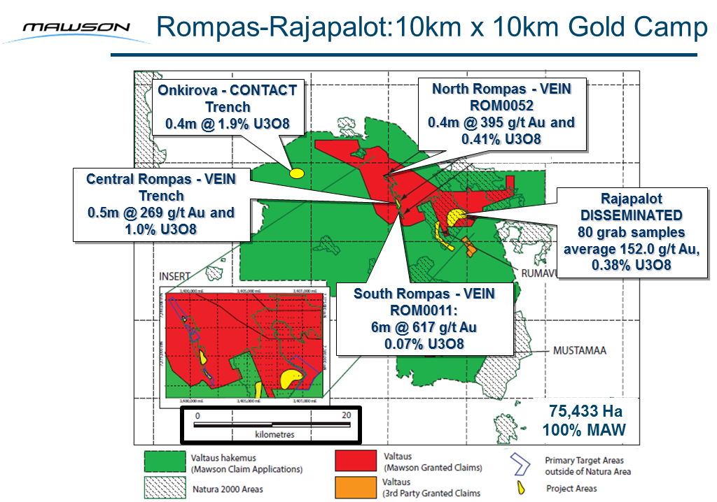
Figure 1: Mawson's 100% owned Rompas high-grade, greenfield gold project located in northern Finland. Further discoveries of multiple and at surface high grade gold anomalies in 2012, such as Rajapalot, has expanded the known gold occurrences to an area greater than 100 km2
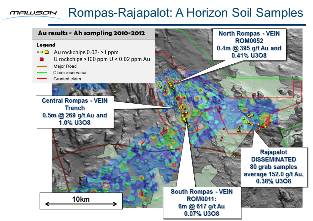
Figure 2: Surface A-Horizon Soil Sampling from Mawson's 100% owned Rompas high-grade gold project. Mawson has collected 2,808 surficial soil and till samples over an area exceeding 55 km by 30 km. Sample spacing has ranged from 1 km to 250 m. Known gold mineralization correlates well with surficial soil anomalies and many untested surface targets remain over a larger area.
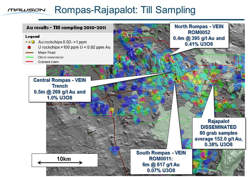
Figure 3: Surface C-Horizon Till Sampling from Mawson's 100% owned Rompas high-grade gold project. Mawson has collected 2,808 surficial soil and till samples over an area exceeding 55 km by 30 km. Sample spacing has ranged from 1 km to 250 m. Known gold mineralization correlates well with surficial soil anomalies and many untested surface targets remain over a larger area.
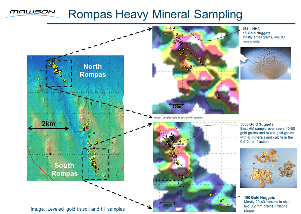
Figure 4: Surface heavy mineral sampling from Mawson's 100% owned Rompas high-grade gold project. Five non-selective 5 litre heavy mineral samples were collected, with one from South Rompas returning one of the largest accumulations of gold nuggets ever identified within a heavy mineral sample from the Fennoscandian Shield. Other samples included one sample up-ice direction with 18 nuggets, 100 m north-west of the last outcrop in North Rompas
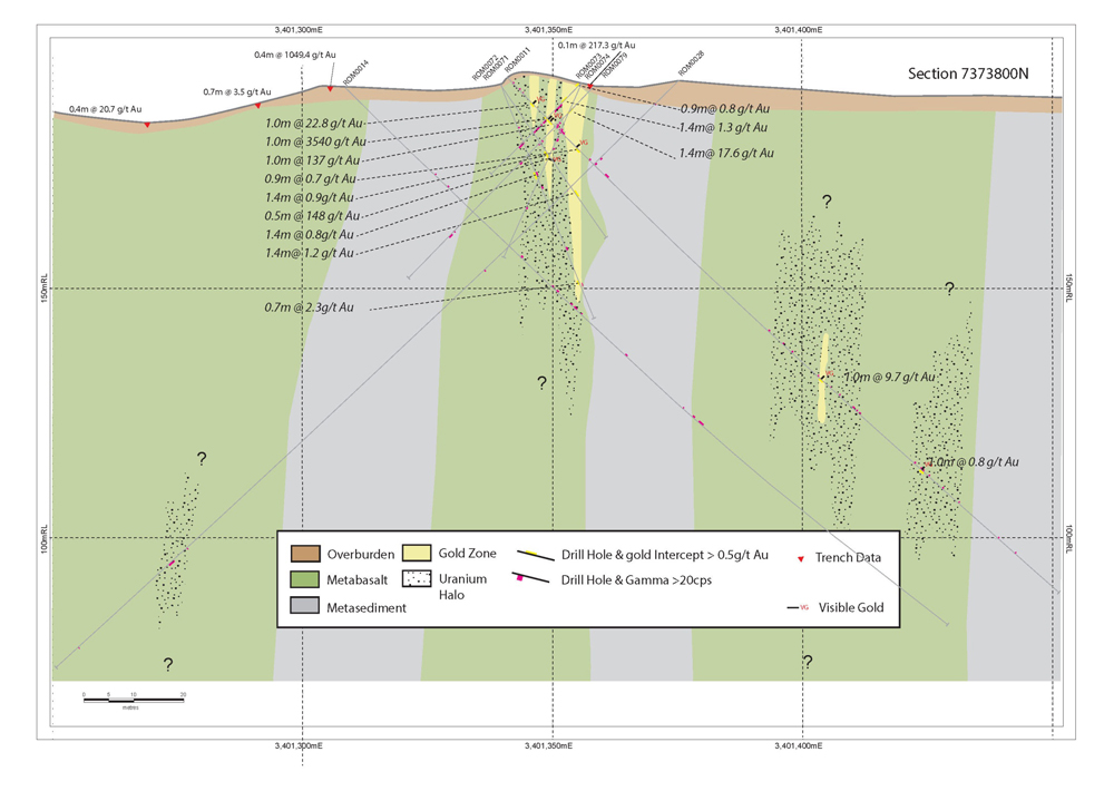
Figure 5: Cross Section 7373800N from the northern drill block in South Rompas
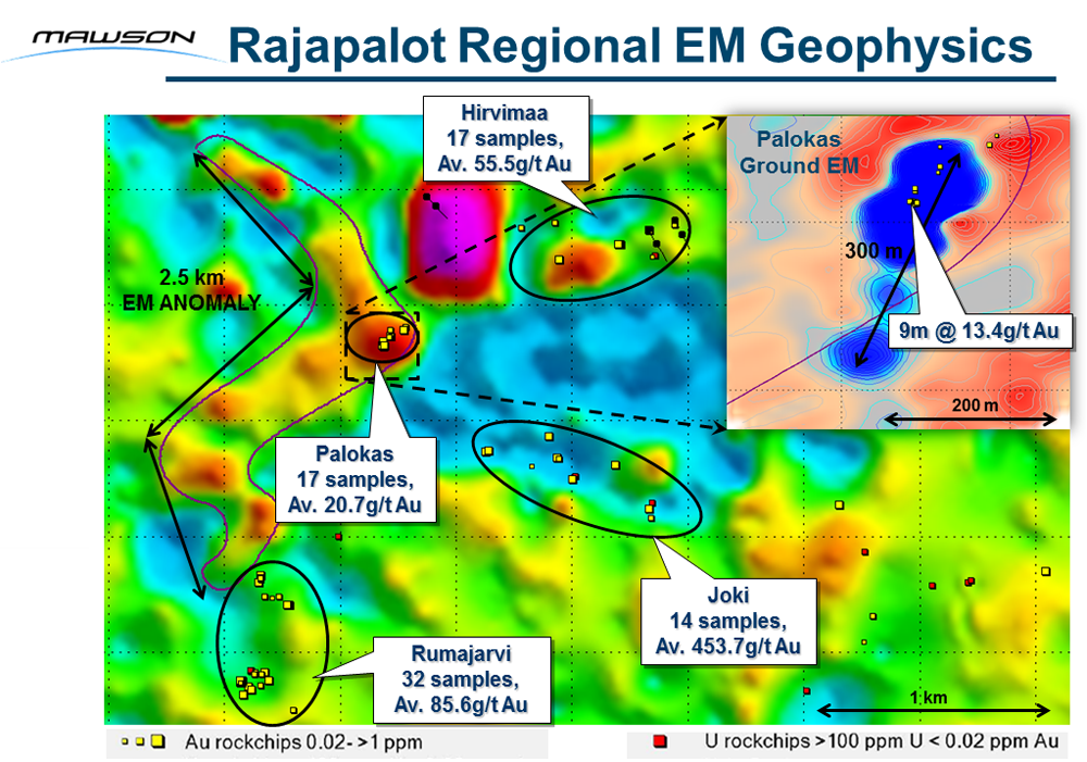
Figure 6: The Rajapalot project with airborne EM data (Slingram Real Component) and inset ground EM data with surface geochemical summary. The most significant feature is a 300 m long by 30 m wide conductor that was defined under the widest zone of continuous gold mineralization found at Rompas to date, at Palokas where rock chip sampling across a strongly altered outcrop averaged 13.4 g/t gold and 226 ppm uranium over 9 m. The regional airborne EM survey shows a conductor above the ground survey at Palokas and also suggests this conductor continues to further mineralized areas over a strike of 2.5 km to the Rumajarvi prospect area.